The winter of 2026 has transitioned from a seasonal chill into a historic meteorological event. A relentless series of atmospheric disturbances, recently punctuated by the arrival of Winter Storm Hernando, has redefined the limits of northern weather. While coastal cities are accustomed to the occasional dusting, the current trajectory of these systems suggests a rare convergence of arctic air and moisture that could dump up to 55 inches of snow in high-elevation corridors and mountain passes. This isn’t just a “snow day”; it is a localized siege that has effectively redrawn the map of daily life across several states.
Infrastructure Under Pressure: Roads and Rail Lines Paralyzed
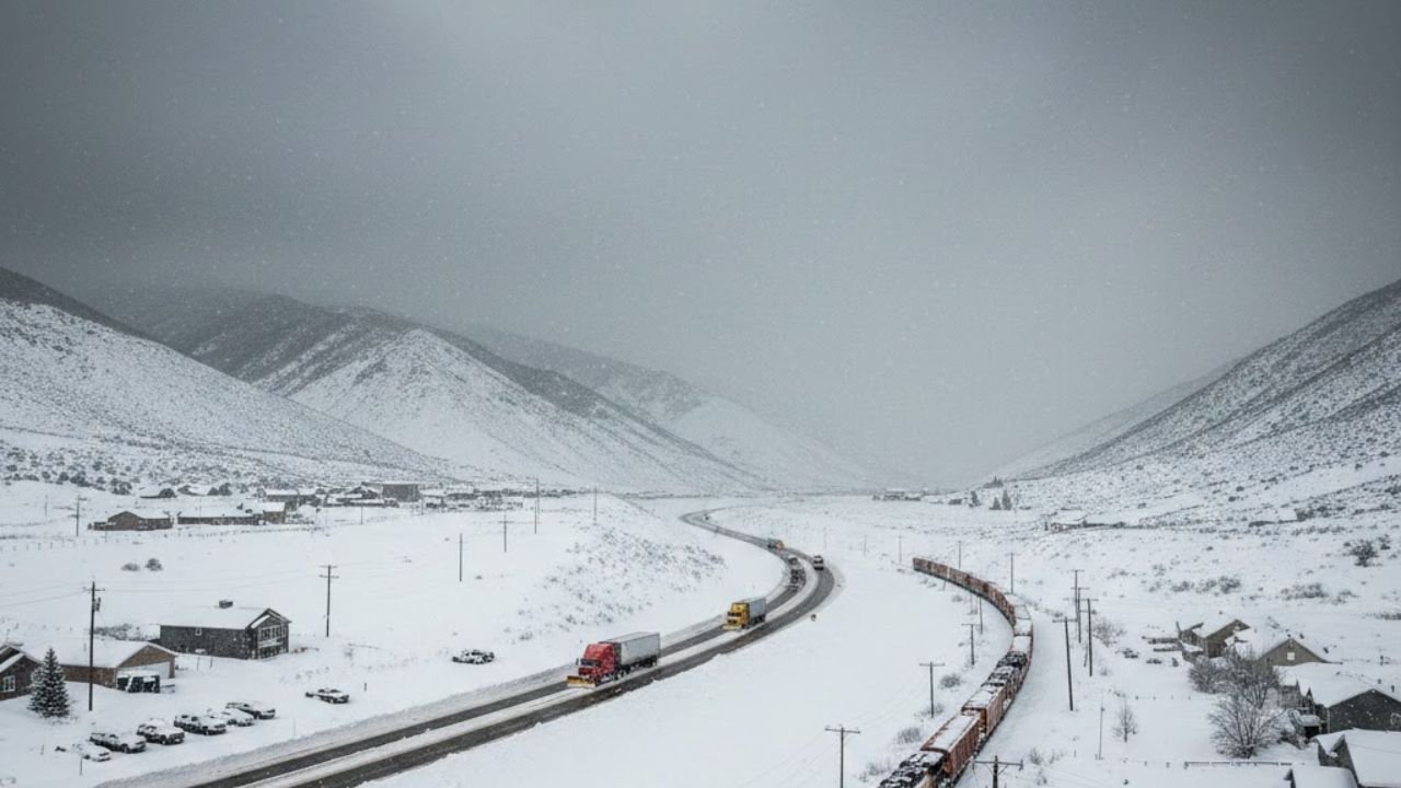
The most immediate impact of this massive accumulation is the total disruption of the nation’s transit arteries. In the Northeast and the Great Lakes regions, transportation officials have moved beyond simple advisories to full-scale closures. Major interstate highways, including stretches of I-95 and I-80, have seen visibility drop to near-zero, forcing state troopers to implement mandatory travel bans. On the rails, the situation is equally dire. Amtrak and regional commuter lines like the Long Island Rail Road have suspended services as tracks become submerged under snow drifts that exceed the clearing capacity of standard equipment.
Summary of Regional Snowfall and Impact
| Region | Peak Snowfall (Forecasted) | Transport Status | Emergency Level |
| New England Mountains | 45–55 Inches | All Mountain Passes Closed | State of Emergency |
| Northeast Corridor (I-95) | 28–38 Inches | Rail Suspended / Limited Bus | Blizzard Warning |
| Upper Midwest | 12–20 Inches | Road De-icing in Progress | Winter Weather Advisory |
| Pacific Northwest | 30–40 Inches | Rail Freight Delayed | Severe Storm Watch |
The “Bomb Cyclone” Effect: Why This Storm is Different
Meteorologists have classified this recent surge as a “Bomb Cyclone,” a phenomenon where atmospheric pressure drops with staggering speed. This rapid intensification creates a vacuum effect, pulling in bone-chilling arctic air and mixing it with Atlantic moisture. This cocktail results in snow rates of 3 to 5 inches per hour, a pace that makes it impossible for even the most sophisticated snowplow fleets to keep up. When you combine this volume with wind gusts reaching 60 mph, you get the perfect recipe for whiteout conditions that render even a short walk to the mailbox life-threatening.
Economic Ripple Effects and Supply Chain Stalls
Beyond the physical inconvenience of being “snowed in,” the economic toll of a 55-inch storm is staggering. Supply chains that rely on just-in-time delivery are seeing massive bottlenecks as cargo trucks remain idling at rest stops. Freight rail, the backbone of inland commerce, has slowed to a crawl. For industries ranging from retail to energy, the “Winter Siege of 2026” represents more than a weather event; it is a significant disruption to the GDP. Businesses in the path of the storm have largely transitioned to remote operations, though widespread power outages have made even digital work a challenge for many.
Record-Breaking Totals: A New Benchmark for Winter
For cities like Providence, Rhode Island, and parts of Massachusetts, the current totals have already shattered records that stood for nearly half a century. We are no longer comparing this to the “Great Blizzard of 1978” because, in many metrics, the 2026 event has surpassed it. In areas where the snow has reached the predicted 55-inch mark, rooftops are under immense stress, and emergency services are utilizing specialized snow-cats to reach stranded residents. This level of accumulation represents a once-in-a-generation climate anomaly that will likely be studied by climatologists for years to come.
Power Outages and the Race Against the Cold
As the heavy, wet snow clings to power lines and high winds snap frozen branches, utility companies are reporting hundreds of thousands of customers without electricity. Restoring power in the wake of a 50-inch snowfall is an uphill battle. Linemen often cannot access the damaged infrastructure until roads are sufficiently cleared, leaving families to rely on wood stoves and generators. Local governments have opened “warming centers” in municipal buildings equipped with back-up power, urging residents to check on elderly neighbors who may be struggling in the sub-zero temperatures following the storm.
Looking Ahead: The Long Path to Recovery
Even as the snowfall tapers off, the recovery phase will be measured in weeks rather than days. The sheer volume of snow—mountains of it piled on street corners and parking lots—requires a massive logistics operation to move. City planners are now faced with the challenge of “snow removal” versus “snow plowing,” which involves hauling tons of ice to designated melting sites. Until the rail lines are de-iced and the primary highways are stripped of their white blankets, the rhythm of the continent will remain stuck in a frigid, snowy limbo.
FAQs
Q1 How much snow is actually expected in the hardest-hit areas?
While coastal cities may see between 20 to 30 inches, high-elevation areas and certain mountain corridors are bracing for up to 55 inches of total accumulation due to the storm’s slow movement and moisture content.
Q2 Are trains and flights being cancelled?
Yes. Most major airports in the Northeast (JFK, Logan, Newark) have cancelled thousands of flights. Amtrak has suspended its Northeast Corridor service, and many regional rail lines are currently inoperative
Q3 Is it safe to drive if I have an SUV or 4WD?
Authorities strongly advise against all non-essential travel. Even with 4WD, the lack of visibility and the depth of the snow (which can exceed a vehicle’s ground clearance) make it very easy to become stranded.